Back In Leicester Again Part 6 — An Industrial Heritage

One of the areas I had marked down to explore on this visit was a swath of streets that are definitely less travelled by tourists, most people would only walk them if they had to go to a business there, or are passing through to go to where they live. I wanted to take photos of the industrial areas that sit between the Grand Union Canal to the west, and Vaughan Way / Burleys Way / Belgrave Gate in the east. Some of which I doubted I had ever walked down myself.
Although I pass some of the historic buildings on this walk, I’m not including them here, as the Jewry Wall, St Nicholas, All Saints, St Margarets, St Marks, Great Central Station, Shaftesbury Hall, etc, as they have been covered in other pieces plenty of times in the past by me. I head down Holy Bones and Welles Street, briefly turn onto Bath Lane before heading back to the old railway track by going up Blackfriars Street onto Jarvis Street where the old railway arches can still be seen, and some are in use. The arches are on the Local Heritage Asset Register (LHAR).

As is the former generator house on the other side of the road. It is trying to rain, and it doesn’t want me to get a picture of this building without a raindrop on the lens. Three times I clean the lens and take the photo again, and each time a raindrop hits the lens as I click.

I walk under the bridge with all its street art and back up Great Central Street, turning on to Friars Causeway where Central House (on the LHAR) is on the corner.

This brings me back to Vaughan Way, where the large tin foil covered cinema is across the road from me.

I turn down Highcross Street, and pass All Saints, and to the junction where this curved building separates the join of Highcross Street with Great Central Street. It says it is open as usual, but looks anything but open.

Soar Lane has changed no end since the last time I walked down here (although that would undoubtedly have been in the dark whilst drunk). And new build are all around.

I go as far as the canal and Stevenson’s Lift Bridge

which has an information board.

Turning around I continue around the new builds here along Swan Street and Pingle Street. It still looks and feels too new, like a pair of trainers you don’t really want to go out in the wet in. Once out on Northgate Street I head back to Sanvey Gate and into the industrial units. I’m not sure when it became the New Joiners, but it doesn’t look as if has improved any over the years.

When I get to Craven Street I turn there and keep turning at each left turn opportunity, wandering around lots of dead-end streets and having to turn back on myself. There are plenty of two and three story brick builds along here in a late Art Deco style. Most of the units look to be in use, and it is a pocket where none of the buildings or plots have been turned to residential use yet. Don’t tell De Montfort University this place is here.

It never registered that Friday Street went under St Margaret’s Way, but I must have known this at some point and been under there in the past. All the walls of the road and the footpaths are covered with street art, an improvement on the grey concrete walls. Once under St Margaret’s Way I turn up Bay Street and then South Church Gate to come back past the church and then head along Canning Place, where the former Leeson’s factory stands, one of numerous buildings in this area which are on the LHAR.

I turn to go up Grafton Place, but from the corner there is a good view of the entrance into the former Corah works where it looks as if more windows have been put through than survive.

Coming out opposite the bus station there is a view up to the original motor hotel, which looks to be in a sorry state.

At the Corah Works brick corner building I turn back into the industrial estate along St John Street and into the quad in the middle of the old Corah buildings. A lot of the buildings around here are on the LHAR, but they are in a sorry state.

It is interesting to be able to get in and have a wander around, something that we would never have been able to do as kids when it was in full flow, the entrance in would have been gated off with security on patrol.

There are a lot of little businesses in here, and whilst it is good that the buildings are being used, there really should be more of an effort to keep it in better repair all around.

The same could be said for any number of buildings as I head on going down Watling Street, this one was definitely not built by the Romans though.

At the end I am back on Friday Street, and the arts centre sits in another LHAR building which used to be a former corporation depot. The Abbey Walk footpath to the park is temporarily closed. It was a route well walked when younger, but only ever it seemed when leaving Abbey Park, never when we were going there.

A lot of the buildings look even worse for wear when seen from the back.

There are plenty of places where you can see where the next street to look down is, but you can’t get through. There are a lot of dead ends, and fences I will be on the other side of which in a few minutes. I can understand them not being open for cars, as it could easily become a kind of racetrack, but it would be nice if some pedestrian routes could be opened and there wasn’t the need to keep retracing steps to get all the way around.

Back on Burley’s Way the flyover is off over and around the bend, and Thames Tower, the former Land Registry building, now flats, looms in front of me.

On the other side of the road is this forlorn looking unit.

I turn down Thames Street, and there are more of the low slung, almost Art Deco buildings along here.

It is a dead end, but there are a couple of places where I can see another road just feet away on the other side of a fence. I retrace steps and then go along Yarmouth Street, Navigation Street, Gas Street and onto Charter Street where it runs alongside the canal.

A route which takes me around most of the Kapital building, another on the LHAR, and a fascinating shape and colour.

It also takes me to the back of the Mattioli Arena, and the new (to me) footbridge over the canal and into Abbey park, with its multi-coloured path.

I make my way along Archdeacon Lane, with the metal flowers on the land between it and Belgrave Gate,

Around St Mark’s and down Memory Lane. And I rack brains to think of the name of the former pub across the road.

To the front of the Mattioli Arena. I’m not sure what was on that day, but the number of portly blokes in bright polyester tops would suggest it was a darts tournament.

I don’t think I ever came down here, it would have all been part of the Charles Keene college campus. I cut between buildings and out to what is now called Memory Lane Wharf.

And then back up to Belgrave Road. The Woodsman is new (to me again), it has been driving me nuts trying to remember all the pub names of places that have gone, but this was a horrible red brick seventies pub whose name escapes me entirely.

Across the road the Bridle Lane has lost the tavern part of the name, and doesn’t now advertise BLT down the outside of the building.

Having crossed Belgrave Road I’m staying in the industrial areas, by going up Lower Willow Street and turning onto Wanlip Street. There are more big old units here, such as Gossamer.

And lots of Crittall windows in other units.

My mum worked in one of the smaller factories down one of these side streets just off Belgrave Gate. Whilst on the other side of the road St Matthew’s appears with its maisonettes on streets all named for places in Canada.

Bedford Street North and Wharf Street North branch off from here,

and I go along Bedford Street North and pass George Street. It reminds me that I did know someone who lived down here in the early nineties. And that it was a surprise to me there were houses down there, until I went round, I always thought all of those side streets off the Belgrave Gate were industrial units only.

I’m back at the flyover now, and I do like the artwork on all the supports under it and how the crossings under it have improved no end.

As I go under it there is the Leicester Square building on the corner, another LHAR entry, and originally a Methodist chapel and school.

I go around the back onto Royal East Street and there is the back of the forlorn building I saw from the other side of Burley’s Way about three quarters of an hour before.

Right down at the end in the corner was a spot I saw a lot of as a kid. It was one of the fire exits from St Paddy’s Club, and had the sloping doors covering the cellar. We would often slide down them when bored of sitting around inside the club with parents.

I turn along Orchard Street and up to Belgrave Gate again, with the old Red Cow pub on the corner.

One of these buildings further along had used to be the Bowlturners, but its unrecognisable now.

Across the road are two other buildings which used to be pubs, and I can’t drag the name out of my head for either of them, the Sultan rings a bell, and The Black something or other (Swan?).

I turn up Gower Street and into Bedford Street South. I know that one of the buildings along the east side of the street used to be the Art Pattern Knife Company, but nothing matches my memory. My grandad used to work for them, and I came to visit him there a couple of times.

There are some nice old buildings along here, but again a lot of them are looking a bit uncared for.

The curved building — almost circular, on the corner of Bedford Street South and Charles Street is more striking than I remember, perhaps it’s the darker windows and not the brightness of travel posters from when it used to be a travel agent.

I pass the job centre, which I was surprised to see was open, I never knew they had started opening on Saturdays. Behind it is the now abandoned Lower Hill Street crown building, which was one of the old DSS offices (amongst other government departments).

Along here, a possible claimant has given it all up, and just left their wheelchair behind.

And then I am out onto Lee Circle, and the Auto Magic car park, the first such in the country and opened by Sid James.

To the north of it is Fleet House, under renovation, and another LHAR building.

I go down Byron Street, then Dryden Street and up Old Milton Street. I’m sure that there used to be another pub here somewhere, but the exact location and any chance of a guess at a name are long gone.

On Wharf Street South there are a cluster of LHAR buildings. This large one on the corner of Wheat Street.

And across the road from it this one which looks as if it should have been a pub / hotel, but was a nineteenth century boot and shoe factory.

It would seem that all that remains of the Prince of Wales pub is the sign on the outside wall. And on the other corner across from it to the rear of the photo, I’m sure that was another pub as well (no hope of guessing the name). I think I need to go Flickr and have another good look through the album by Chris Pyrah as I’m sure they will all be listed on there.

I had forgotten just how impressive the Lee Street telephone exchange building was. Completed in 1959, it is very much in an Art Deco style, and is huge.

Behind it I was expecting to see the rear of the Lee Circle car park, and on the ground level the former favourite nightclub The Aviary, but instead there are more apartment buildings here.

I do a loop around Eldon Street, Camden Street, Earl Street, and up St James Street passing more big former industrial red brick buildings.

I pass the sorry looking Palais building, and turn along Humberstone Gate passing what used to be Secrets with no sign of where it actually was, and the Notts Oddfellows which somehow survives, then the weighbridge toll collectors house, and the former Three Cranes and the former Central Hotel, and turn into Rutland Street, having passed so much drinking history in two minutes.

Not far along Rutland Street is the brightly painted front to Makers Yard.

And the front of what had been the Pfister & Vogel warehouse. Compare and contrast to the modern concrete and steel warehouses that spring up on brownfield sites nowadays.

The road is blocked off and pedestrians have a choice of which side to squeeze down. This is because the Curve has had bits dropping off it. I choose the side to go down Southampton Street, with the Grade II listed Alexandra House on the corner.

On the next corner is Deuce House,

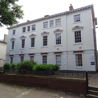
And opposite is another Grade II listed building — Wimbledon House.

I turn down Morledge Street to look at the street art which abounds around here, and notice a red plaque up on the wall of the building. A commemorative plaque to fire fighter Robert Miller who died in the line of duty.

Along Midland Street and opposite the Phoenix Theatre, the buildings are all covered with Bring The Paint works, and it extends into a parking garage along there as well. I go along Nichols Street and round onto St George Street. There is a modern looking building between me and St Georges Way, but it isn’t what used to be there. There is no Leicester Mercury building with its clock and temperature showing to all passersby. On the other side is the side of the Rowley Building.

The front of which is round the corner on Queen Street.

There are information boards along here to the Queen Street Fire and GH Wait & Co, and the old frontage to the more modernly created Queen Street Apartments, with the old St George’s Church in the background.

I turn back into Rutland Street at the other end of where it is blocked off, and where Halford Street angles off from it is this building which makes me think of the similar looking Flatiron building in New York. This is the Exchange Building, a Grade II listing designed by Stockdale Harrison.

On Rutland Street the modern looking brick LCB building is what had used to be the Corporation Bus Depot. I remember being confused as a child when a bus I was on took a detour and came into the depot for a driver change.

It seems every corner has a grand building on, and Premier House on the corner of Colton Street is yet another Grade II listed building.

I wander up and down Wigston Street, Yeoman Street, Rutland Street, and Halford Street as far as Charles Street taking photos of the array of different styles and grand looking buildings.

Sixes is a riot of colour below the car park and what had used to be another DSS office.

On the ground in Halford Street is a CQ Art trail map, which I don’t take up.

There are also two plaques on the ground, they appear to be all that are left of the twelve that were initially installed to famous Leicester people.

I head down Yeoman Street passing another red brick behemoth, which is locally listed and pop out back on Humberstone gate.

It is time to head back to the hotel and refresh before the afternoon wandering starts. It was an interesting walk for me, and definitely roads less travelled by most people, but there is so much of Leicester’s industrial heritage hidden away just beneath the surface of the main roads, and many monuments to it in the buildings that remain.
All the other pieces relating to my 2024 Leicester trip are in this library.

If you liked this post, follow me or get on my email list for future posts. Some may even be more enjoyable than this one.
You can find articles I have already published here.
And feel free to clap (any will do), or highlight (pick something at random), or comment (any old gobbledygook will do), or best yet all three.
